Parangalitsa Biosphere Reserve in Rila
Parangalitsa is one of the four reserves included in Rila National Park . The territory covered by the protected area has been evaluated since Ottoman times. At that time in the forests of Parangalitsa only the highest ranking dignitaries were allowed to hunt game. The hunting license was issued only by the Sultan, and he alone could determine who to hunt and who not to hunt.

It is supposed that precisely because of the strict observance of the Sultan’s orders concerning the conservation of this territory, it was called “Parangalitsa” (The word is Greek and in translation means “forbidden”, “protected”, “reserved” place) .
When was it created?
After the Liberation , the forests in the reserve are scrutinized by native and foreign experts, who find that some of the oldest spruce forests not only in our country but also in Europe are located on its territory.
In order to preserve them and to preserve the ecosystem in the southwestern part of the mountain , in 1933 the Ministry of Agriculture issued an Order declaring Parangalitsa a reserve.
In 1977 it was designated by UNESCO as a Biosphere Reserve and in 1979 it was included in the UN list of the International Union for the Conservation of the Environment.
Where is?
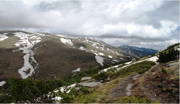
Parangalitsa Reserve is located in the southwestern parts of Rila Mountain. It is situated at an altitude of 1400 to 2480 meters above sea level and covers an area of 1509 ha. Its boundaries are defined:
- north of the Bistritsa River
- west of the Hajdushka River
- to the south and east of the Mechi Pass passage and the ridges of Peaks Ezernik (2485 m), Parangalitsa (2419 m)and Merdzhika (2484 m)
Relief, soil and climate
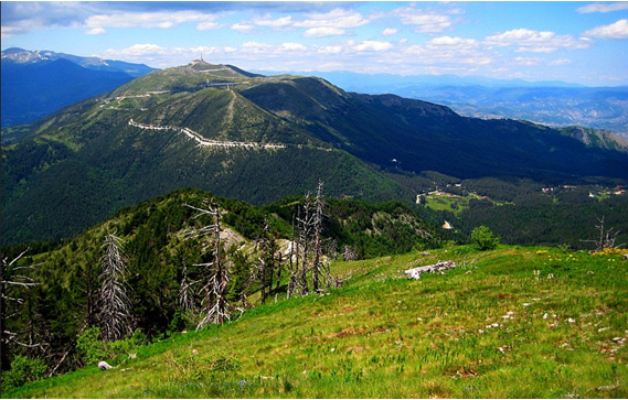
The relief of the Parangalitsa Biosphere Reserve is mountainous with large vertical divisions due to the large difference in altitude of the territory it covers.
The rocks are mostly granite or granite – gneiss , and the soil (again due to the almost 1000 meters difference in altitude) varies from mountain meadow and mountain forest to brown forest soil .
The climate is mountainous with average annual temperatures of 4.5 degrees C.
Plant and animal diversity
The combination of geological, climatic, soil and geomorphological features of the protected area create excellent living conditions for diverse representatives of flora and fauna.
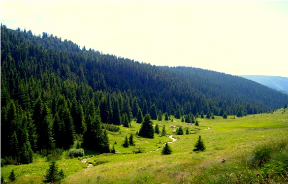
Of the 1509 hectares of area included in the reserve, forest areas cover 256.6 ha, 75% of which are spruce forests . In addition, white pine, fir and beech forests are growing in the protected biosphere territory, as well as mixed forests ofspruce and fir, spruce and white pine, spruce and beech and others.
On the highest parts and rocky slopes of Parangalitsa there are large squat stands, alpine grasses and shrubs.
An interesting fact is that in spruce forests, researchers have found some of the tallest, tallest and oldest trees , the age of which has been determined from 120-150 to 350- 380 years.
Nearly 300 higher plant species , some of which are so valuable to be recorded in the Red Book, can be seen on the territory of the Biosphere Reserve.
Here grow the Osamodian tulip, mountain peony, speckled tinted, golden bucket, yellow tinted, toothpick, male and female fern, lazarkinia, rabbit sorrel, woodpecker, white cherry, Bulgarian enchantress, easter, alpine taciaand many others.

The animal diversity in the reserve is also huge. Parangalitsa is very rich in both large and small animals and various ornithological species :
- Of the large animal species, bears, deer, deer, wolves, feral cats, feral pigs and foxes can be seen here .
- From their smaller brethren, who live in the protected territory, there are hares, squirrels, drowsies, golds, squirrels, blind dogs, moles, forest mice, voles , etc., etc.
- Of the birds, the most common are the king’s eagles, sorghum, thrush, capercaillie, tit, lark and more.
- The reptiles that have found a home in the reserve are the blind, the viper, the mead, the meadow, the green and the live lizard, and the most common amphibians are the raincoat and the toad.
Conservation of the biosphere reserve
In order to protect the Parangalitsa ecosystem in its original form, no activities are permitted on its territory. Exceptions are activities such as:
- security
- extinguishing forest fires
- research activities
- passing tourists along designated routes
There are several hiking trails that any hiker can take, but we will introduce you to the most popular of them: From Macedonia Hut to Predela Hut.
Many tourists pass this route, especially during the summer months, as it is extremely attractive, places challenging and the views revealed during the transition to the nearby peaks of Rila are worth every effort.

From Macedonia Chalet to Predela Chalet – 26 kilometers of beauty
The starting point , as we mentioned, is from Macedonia hut , after which you should take the path marked in red and walk on it for about 1 – 1.5 km. The trail is well-trodden, the climb is not great and you can easily walk the distance.
About 1 – 1.5 km. you reach a fork that is highlighted in blue, but you should continue to follow the red mark. You will pass near the peak of Merdzhika (2485 m) , where you can relax and enjoy the beautiful view that opens from there.
After getting some air, you should continue to the Kapatnik peak (2170 m) . The load from Merjika peak to Kapatnik peak is not very large, the trail is well marked, so you can enjoy the hike and soak in the beauty of Rila .
Getting to Kapatnik Peak is good for a good rest as it follows the heavier part of the route . A steep descent down an unmarked path awaits you and you need to be extra careful.
You can only rest when you reach the river Mrazenitsa , where the path becomes again relatively flat and pleasant to walk. Then you are about 6 km away. to Predela hut, which are extremely easy to reach.
The route is about 26 km long. and it will take about 8-9 hours to get past it. The transition is not suitable for beginner mountaineers because it has a large displacement.
How to get to Parangalitsa Biosphere Reserve?
The closest settlement to the reserve is Blagoevgrad . If you are coming from the capital, you should first reach Blagoevgrad, then take the direction of Bodrost hut , from where you can start the transition from the reserve.
If you are vacationing at a hotel in Bansko , you should again go first to Blagoevgrad, then to the Bodrost hut. You also have another starting point from the village of Dobarsko , from where you can make a hike to Macedonia.
Sightseeing places near Parangalitsa Reserve
Rila Monastery
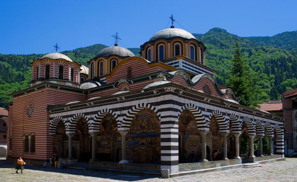
The Holy Monastery is not only one of the most popular places to visit, but one of the most striking symbols of Bulgaria . Founded in the 10th century by St. John Rilski, several times destroyed and rebuilt, the Rila Monastery has been, is and will be one of the greatest shrines in our country. The Rila Monastery can be reached by asphalt road from the village of Kocherinovo as well as by passing from the chalet of Macedonia.

Markov stone
The Markov Kamal Megalithic Sanctuary is located below Tsarev Peak. The sanctuary is a cult megalithic complexwith a total length of 5 km. According to its discoverers, Markov stone is a pagan complex that played an extremely important role in pre-Christian times.
The sanctuary can be reached from the Bodrost hut . From there the hiking trail to be followed. Markov Stone can also be reached from Macedonia Chalet.